Whitehorse Rabbit’s Foot Canyon, Yukon
Canada
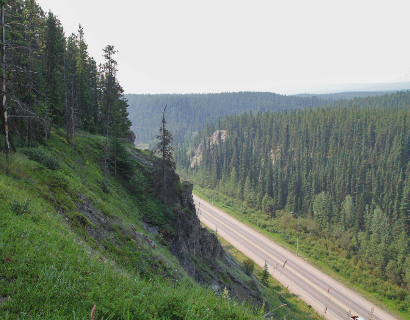
Alongside Momentum, LAND developed a study at the request of the Yukon Government for Rabbit’s Foot Canyon, part of the Whitehorse corridor and a key component of the broader Alaska Highway Multi-use Trail Masterplan. This proposal aims not only to improve safety and connectivity across the corridor but also to enhance economic development and tourism opportunities for the territory, aligning with a strategic vision that integrates ecological, social, and cultural values.
This vision transcends infrastructure rehabilitation by proposing a holistic, multi-dimensional approach that fosters coexistence, resilience, and experience within the landscape. This means supporting wildlife movement and biodiversity, enhancing ecosystem resilience especially regarding water systems, and enriching human interaction through accessibility and valorization of the local unique assets.
These include the cultural and natural heritage of the Chasàn Chùa Park, which is vital for the project’s long-term sustainability. By recognizing and respecting this legacy through collaborative governance with Indigenous communities, traditional knowledge will be actively integrated into the development process.
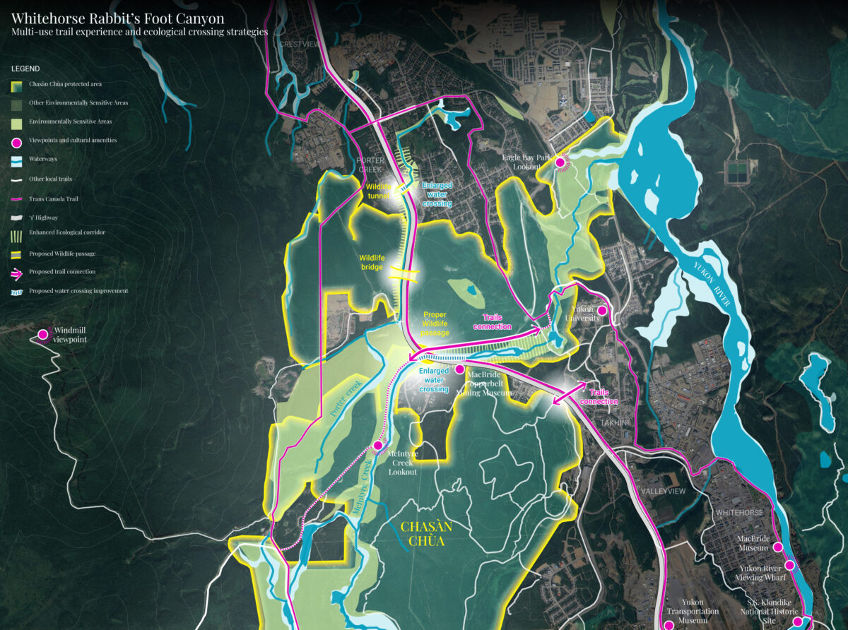
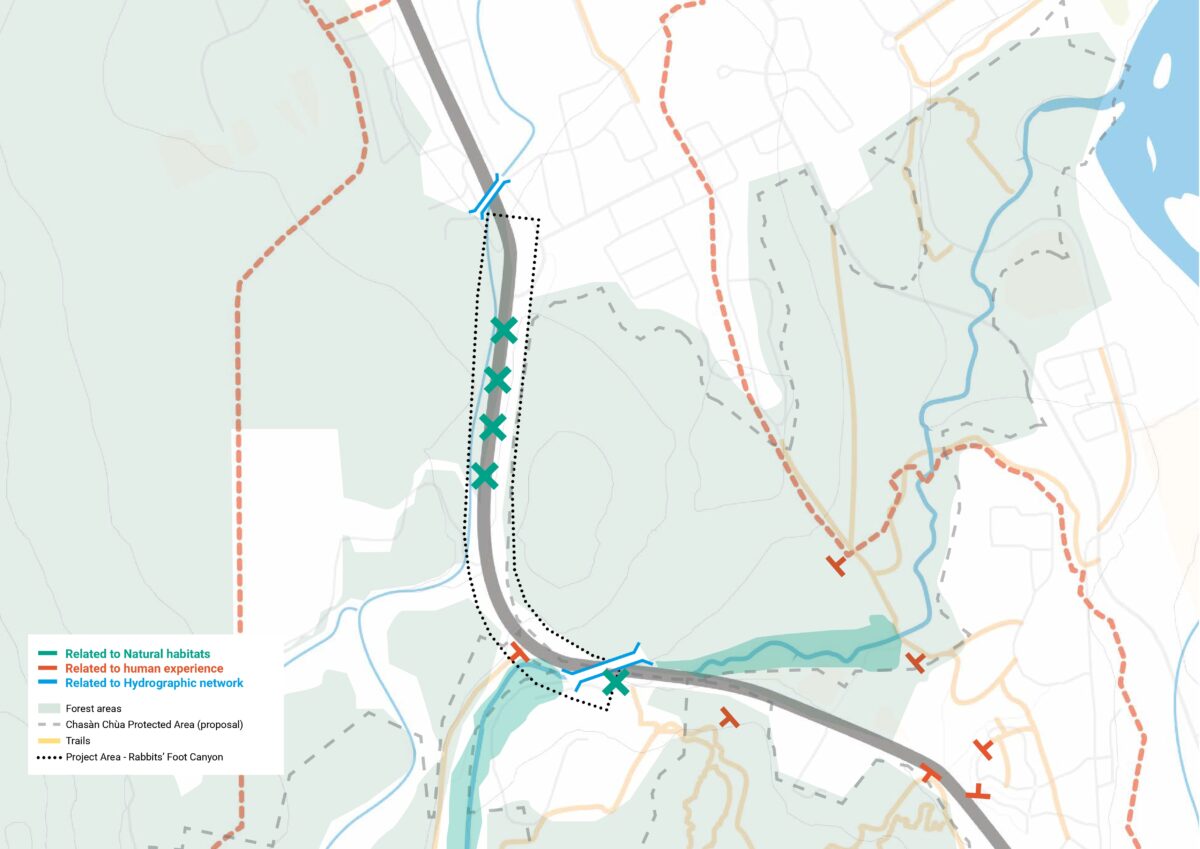
A discontinuity caused by the highway and a fragmented vision
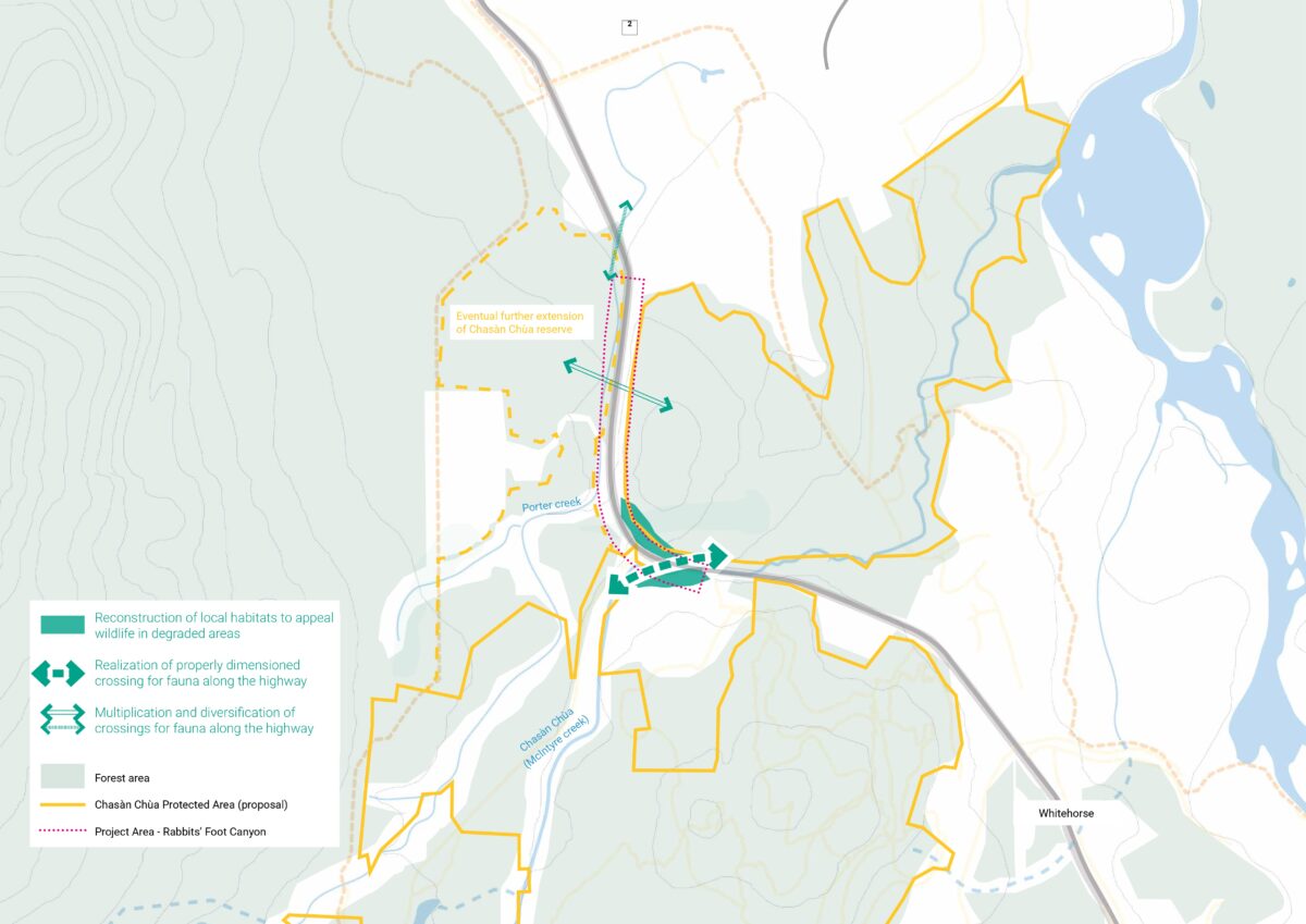
Provide continuity to the Environmental network
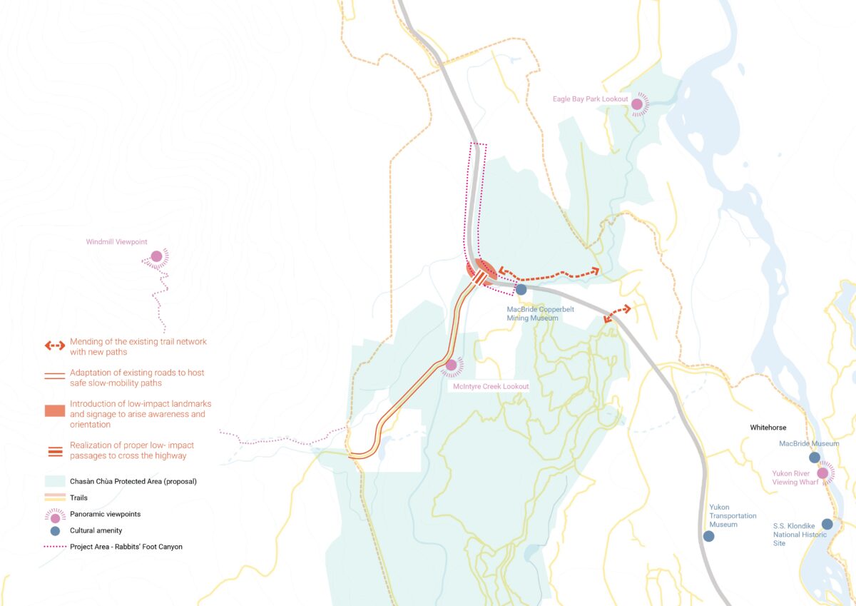
Enhance the cyclo-pedestrian experience
Improve hydrographic resilience
Through thorough contextual analysis, LAND identified three interrelated challenges linked to the presence of the highway in a high-value ecological area, including the McIntyre Creek riparian ecosystem:
- Habitat fragmentation
- Trail network disruption
- Hydrographic constraints
These three topics led to the development of a comprehensive, three-dimensional strategy, as outlined in the landscape manifesto. LAND’s holistic vision identified new and unprecedented potential, integrating it with infrastructure improvements and turning such constraints into opportunities.
Restoring continuity in the environmental network
Continuity is crucial for the survival of the 17 mammal species along with fish and amphibians observed in the area, including both large and small fauna. The plan aims to ensure continuity while advancing and surpassing the existing infrastructure by implementing scaled wildlife crossings to ensure safe movement across the corridor, enhance ecological permeability and reconnect fragmented landscapes.
Enhancing the cycling and pedestrian experience
The strategy advocates reconnecting fragmented trails and adapting existing infrastructure to support slow mobility and non-motorized users. Low-impact landmarks and signage will improve orientation and safety. It aslo includes the creation of highway crossings specifically designed to be low-impact and compatible with the surrounding environment, reducing interference with road traffic.
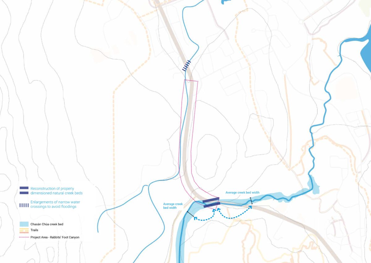
Improving the area’s hydrographic and natural resilience
Reconstructing creek beds to their natural dimensions and widening narrow water crossings will restore the original flow, reduce flood risk, and support better water management. Recommendations include minimizing the impact of infrastructure works on existing natural and wildlife areas of great value and significance.
A key element of this strategy is its integration with Chasàn Chùa (“Copper Creek” in Southern Tutchone), recently recognized as a territorial park after 15 years of dedicated effort: an achievement that honors the timeless importance of this place for the local community. For thousands of years, this area has sustained diverse wildlife and has been central to Indigenous peoples, whose stewardship has shaped and protected this land throughout history.
Office
People
Valeria PagliaroFederico BressanelliAndreas Kipar Sharen Delgado Iglesias
Typology
Sustainability ConsultingStrategic masterplanning at all scalesCultural heritage & tourism
Related projects
Strategic Campus Development Framework, Schaeffler Areal Herzogenaurach
Strategic Campus Development Framework, Schaeffler Areal Herzogenaurach